
Planck’s Blackbody Law
Planck’s law is a formula that describes the spectral radiance of a black body, which is an idealized physical body that absorbs all electromagnetic radiation that falls on it and does not reflect any. This law is important in the field of thermal remote sensing, which involves using sensors to measure the temperature of an object or surface from a distance.
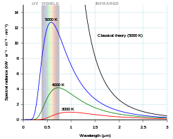
In particular, Planck’s law describes how the intensity of electromagnetic radiation emitted by a black body depends on its temperature and the frequency of the radiation. The formula for Planck’s law is:
B(T, v) = (2hv^3)/(c^2)(1/(e^(hv/kT)-1))
where B is the spectral radiance of the black body, T is the temperature in kelvins, v is the frequency of the radiation, h is the Planck constant, c is the speed of light, and k is the Boltzmann constant.
Thermal remote sensing systems often use sensors that are sensitive to certain frequencies of electromagnetic radiation, such as those in the infrared or microwave range. By measuring the intensity of radiation emitted by an object at different frequencies, it is possible to infer the temperature of the object. This information can be used for a wide range of applications, including monitoring the temperature of the Earth’s surface, detecting fires, and measuring the temperature of industrial processes.
Displacement Law and emissivity effects
The Displacement Law states that the wavelength at which an object emits the most radiation is inversely proportional to its temperature. This means that as an object’s temperature increases, the wavelength at which it emits the most radiation decreases. This law is important in thermal remote sensing because it helps to determine the temperature of an object based on the wavelength of the emitted radiation.
Emissivity is a measure of an object’s ability to emit radiation. It is a unitless value that ranges from 0 to 1, with 1 being the maximum emissivity. Different materials have different emissivity values, and this can affect the accuracy of temperature measurements in thermal remote sensing. For example, if an object has a high emissivity, it will emit more radiation and therefore appear warmer in thermal images. On the other hand, if an object has a low emissivity, it will emit less radiation and appear cooler in thermal images. Therefore, it is important to consider emissivity when using thermal remote sensing to measure temperatures accurately.
Heat Capacity, Thermal Conductivity
Heat capacity is the measure of how much heat is required to raise the temperature of a substance by a certain amount. It is typically measured in units of joules per kelvin per gram (J/K/g).
Thermal conductivity is the measure of how easily heat is conducted through a substance. It is typically measured in units of watts per meter per kelvin (W/m/K).
In thermal remote sensing, both of these properties are important in understanding the temperature and heat flow of objects and surfaces being studied. For example, if a surface has a high heat capacity and low thermal conductivity, it will be able to absorb and retain heat for a longer period of time. This information can be used to determine the surface’s ability to cool or warm up, and can also be used to predict the surface’s temperature over time.
Thermal remote sensing is often used in various applications, such as weather forecasting, climate modeling, and earth science research. It allows scientists to study the temperature and heat flow of objects and surfaces from a distance, using specialized sensors and equipment that can detect and measure thermal radiation. This information can be used to understand and predict weather patterns, study the Earth’s surface and atmosphere, and monitor changes in temperature and heat flow over time.
Thermal Inertia
Thermal inertia is a measure of the ability of a surface to resist changes in temperature. In thermal remote sensing, this concept is used to understand the temperature behavior of different materials and surfaces on Earth’s surface.
Thermal inertia is typically determined by the heat capacity, density, and conductivity of a material. Materials with high thermal inertia tend to maintain a constant temperature for longer periods of time, while those with low thermal inertia experience more rapid temperature changes.
For example, a sand dune may have a low thermal inertia because it is made up of relatively low-density particles with a low heat capacity. As a result, the temperature of the sand dune may fluctuate rapidly throughout the day due to changes in solar radiation. On the other hand, a paved road may have a high thermal inertia due to its high density and heat capacity, meaning that it will take longer for the temperature to change and it will remain relatively constant throughout the day.
Thermal inertia is important in thermal remote sensing because it affects the temperature of a surface as seen by a satellite or other remote sensing instrument. By understanding the thermal inertia of different materials, scientists can more accurately interpret temperature data collected by remote sensing instruments and use it to better understand the Earth’s surface and its processes.

Diurnal Heat Effect
The diurnal heat effect in thermal remote sensing refers to the changes in temperature that occur throughout the day due to the Earth’s rotation and the movement of the sun. These changes can affect the accuracy of thermal remote sensing data, as the temperature of an object may vary significantly depending on the time of day.
One way to minimize the diurnal heat effect is to ensure that data is collected at the same time of day. This can be achieved by using satellite imagery that is captured at the same time every day, or by using ground-based sensors that are programmed to take measurements at the same time.
Another way to reduce the impact of the diurnal heat effect is to use algorithms that account for the differences in temperature due to the time of day. These algorithms can help to normalize the data and provide more accurate temperature readings.
Overall, the diurnal heat effect is an important consideration in thermal remote sensing, as it can significantly impact the accuracy of the data. By understanding and addressing this effect, researchers and practitioners can improve the reliability and usefulness of thermal remote sensing data.
Thermal Property of Objects
Thermal remote sensing is a technique used to measure the temperature of objects from a distance using infrared sensors. The thermal property of objects in thermal remote sensing refers to the ability of an object to absorb, reflect, and emit thermal energy.
The thermal property of an object is determined by its surface material and its ability to conduct heat. Objects with a high thermal conductivity, such as metals, are able to absorb and emit heat more quickly than objects with a low thermal conductivity, such as plastics. Similarly, objects with a high emissivity, such as dark surfaces, are able to absorb and emit heat more efficiently than objects with a low emissivity, such as light surfaces.
The thermal property of an object also determines its temperature when exposed to different levels of solar radiation. For example, an object with a high thermal conductivity will heat up quickly when exposed to direct sunlight, while an object with a low thermal conductivity will heat up more slowly.
Thermal remote sensing allows scientists to measure the temperature of objects from a distance, which can be used to study the Earth’s surface and atmosphere, as well as to monitor and predict weather patterns.
Thermal Sensors
Thermal sensors in thermal remote sensing are devices that measure the temperature of an object or surface from a distance. These sensors are often used in satellite imagery or aerial photography to gather information about the Earth’s surface temperature.
Thermal sensors work by detecting the amount of thermal radiation emitted by an object or surface. This radiation is emitted in the form of infrared wavelengths, which are invisible to the human eye. The sensor converts these wavelengths into an electrical signal, which is then used to determine the temperature of the object or surface being measured.
There are several types of thermal sensors used in thermal remote sensing, including passive and active sensors. Passive sensors rely on the thermal radiation emitted by the object or surface being measured, while active sensors emit their own energy and measure the reflected energy to determine the temperature.
Thermal sensors are used in a variety of applications, including weather forecasting, agriculture, forestry, urban planning, and natural resource management. They are also used to monitor the health of plants and animals, and to detect hot spots in wildfires.
Overall, thermal sensors in thermal remote sensing provide important information about the temperature of the Earth’s surface, which helps scientists and policymakers better understand and address issues related to climate change and natural resource management.
Thermography
Thermography is a technique used in thermal remote sensing that involves the measurement and mapping of thermal energy emitted by objects or surfaces. It is a non-invasive method that can be used to study the temperature of objects or surfaces from a distance, without the need for physical contact.
Thermal remote sensing systems are equipped with specialized sensors that are able to detect and measure the thermal energy emitted by objects or surfaces in the form of infrared radiation. The sensors are typically mounted on aircraft, satellites, or other platforms, allowing for the acquisition of data over large areas.
Thermography has a wide range of applications, including the monitoring of surface temperatures in agriculture, geology, meteorology, and environmental science. It can be used to detect changes in surface temperature that may indicate the presence of geological features, such as fault lines, or to monitor the growth and health of crops.
In addition to its scientific applications, thermography is also used in various industries for quality control and maintenance purposes. For example, it can be used to identify faulty components in electrical and mechanical systems, or to detect leaks in pipelines and other structures.
Overall, thermography is an important tool in thermal remote sensing that allows for the measurement and mapping of thermal energy emitted by objects and surfaces, providing valuable information for a wide range of applications.
Thermal Image Interpretation
Thermal remote sensing refers to the use of sensors to measure the temperature of objects or surfaces from a distance. This type of sensing is often used in satellite imagery or aircraft-based sensors to study the Earth’s surface and atmosphere. Thermal images, also known as infrared images, are produced from these sensors and can be used to analyze and interpret the temperature patterns of different features on the Earth’s surface.
One common use of thermal remote sensing is to monitor and detect land surface temperature changes. For example, it can be used to identify areas of urban heat island, which are areas in cities that are significantly warmer than surrounding rural areas due to the heat generated by buildings, roads, and other man-made structures. Thermal images can also be used to identify areas of vegetation stress, such as drought-affected areas, and to monitor the health of crops.
Thermal images can also be used to detect and monitor natural disasters such as wildfires and volcanic eruptions. Wildfires can be detected by the heat they produce, and thermal images can be used to track the spread and intensity of the fire. Volcanoes can also be monitored using thermal images, as the heat emitted from the lava and ash can be detected from space.
Thermal images can also be used in the field of meteorology to analyze and forecast weather patterns. Temperature differences between different layers of the atmosphere can be detected using thermal images, which can be used to predict the movement of storms and other weather systems.
Overall, thermal remote sensing is a valuable tool for analyzing and interpreting temperature patterns on the Earth’s surface and atmosphere, and has numerous applications in fields such as agriculture, meteorology, and natural disaster management.


