
Introduction
Buffer analysis is a powerful tool in geographic information systems (GIS) that helps to understand spatial patterns and relationships within data. It involves creating buffers around points, lines, or polygons and analyzing the data within those buffers. This article provides a comprehensive guide on buffer analysis, its applications, and how to implement it.
What is Buffer Analysis?
Buffer analysis is a GIS technique used to identify features or areas that are within a specific distance of a given point, line, or polygon. It creates a buffer zone or area around the selected feature and calculates the data within that area. The buffer zone can be a fixed distance, such as 500 meters, or a variable distance based on another attribute in the data.
Buffering
Buffering is a common analytical technique in GIS that involves creating a zone around a geographic feature, such as a point, line, or polygon. The buffer zone is defined by a specific distance or a variable distance based on other attributes in the data.
The purpose of buffering is to analyze and understand the spatial relationships between features in the data. It is often used in applications such as environmental studies, urban planning, transportation planning, and business analysis.
It is an important function used to determine spatial proximity of various features by defining a distance zone around features. Buffer can be generated for points, lines and polygons
It automatically builds zones with a certain width around point, line, or region geometric objects according to a specified buffer distance. The area that is within the specified distance is called the buffer zone.
There are three main types of buffer analysis: point buffering, line buffering, and polygon buffering.
Point Buffer
A point buffer creates a circular area around a point feature, with the radius of the circle defined by a specific distance or a variable distance based on other attributes in the data. The purpose of point buffering is to analyze and understand the spatial relationships between features in the data that are within the buffer zone.
- Builds buffer for point objects.
- For example, buffers can be built for two radio broadcasting stations to analyze the residential area that can be covered by the signal transmitted from each of the two stations as well as the area covered by signals from both stations.

Line Buffer
A line buffer creates a polygon area around a line feature, with the width of the polygon defined by a specific distance or a variable distance based on other attributes in the data. Line buffering is useful for analyzing and understanding the spatial relationships between features in the data that are within a specific distance of a linear feature, such as a road or a river.
- Builds buffers for line objects.
- For example, suppose two adjacent streets are to be expanded by 20 meters. A buffer analysis combined with a general query analysis can identify the buildings that need to be pulled down before expanding the streets.

Polygon Buffer
A polygon buffer creates a buffer zone around a polygon feature, with the width of the buffer defined by a specific distance or a variable distance based on other attributes in the data. The purpose of polygon buffering is to analyze and understand the spatial relationships between features in the data that are within a specific distance of a polygon feature, such as a park or a building.
- Builds buffers for region objects.
- For example, buffers can be built for rivers and lakes to identify areas vulnerable to floods.
- Buffer can be inside or outside of polygon

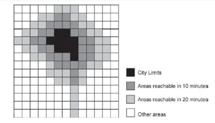
Multi/Multiple Buffer
Multi or multiple buffering is a GIS technique that involves creating multiple buffer zones around a geographic feature. This technique is useful when analyzing spatial relationships between features that are located at different distances from the source feature.
To create a multiple buffer, the user specifies the distances at which the buffer zones should be created, and the software creates a separate buffer zone for each specified distance. For example, if the user specifies buffer distances of 100 meters, 200 meters, and 300 meters, the software will create three separate buffer zones around the source feature, each with a radius of 100 meters, 200 meters, and 300 meters respectively.
- buffer features using a set of buffer distances.

Raster Buffer
A raster buffer is a GIS technique that involves creating a buffer zone around a raster dataset. In contrast to vector-based buffering techniques, which create buffer zones around individual features, raster buffering creates a buffer zone around a continuous surface, such as a digital elevation model or a satellite image.
To create a raster buffer, the user specifies a buffer distance, and the software creates a new raster dataset that extends a specified distance outward from the edges of the original dataset. The new raster dataset consists of pixels that are assigned values based on their distance from the original dataset, with values ranging from 0 (indicating the original dataset) to the buffer distance (indicating the outer edge of the buffer zone).
Raster buffering is useful when analyzing spatial relationships between continuous surfaces, such as identifying areas of land that are within a certain distance of a river or lake. By creating a raster buffer around the river or lake, it is possible to identify the areas of land that fall within the buffer zone.
Conclusion
Buffer analysis is a powerful GIS tool that helps to understand spatial patterns and relationships within data. It has a wide range of applications in various fields, including environmental studies, urban planning, and business analysis. By following the steps outlined in this article, you can implement buffer analysis and gain valuable insights from your data.


