
INTRODUCTION
The application of Geographic Information Sciences (GIS) continues to grow as a global research tool for understanding the world around us. Cartography, the process of making maps, has benefited greatly from advancements in GIS technology in recent years.
The number of students earning degrees in cartography has risen 40% in the past decade to keep pace with the demands of technology and consumer needs. Modern cartography influences our lives in ways that probably don’t seem obvious to most of us. Services that are simple for users, such as ordering rideshare from apps like Uber or Lyft are only possible due to innovations in modern cartography.
Geographic information systems (GIS), the ultimate culmination of cartography and modern technology, allow us to map our world like never before: from rendering 3D oceanic base maps to find the nearest dry cleaner.
Modern cartography has led to the creation of numerous digital tools that enhance the accuracy of traditional maps. One example is a new technology that addresses color blindness by allowing GIS experts to see what a map looks like to a color-blind individual.
WHAT IS MODERN CARTOGRAPHY?
Modern cartography might seem like a contradiction when considering the historical origins of cartography and traditional map-making. However, cartography remains as relevant as it was centuries ago thanks to the advent of GPS, data globalization, and location analytics.
Modern cartography allows GIS professionals to understand everything from climate change to where companies should open businesses. And, the possible applications extend far beyond our own planet. For example, this interactive map shows how new star charts and celestial coordinates can be discovered all through modern cartography techniques.
Maps in modern times
Maps evolved significantly with the rise of geospatial technology: breaking new ground with the advent of Google Earth.

Past cartography tools include compasses, mylar sheeting, planimeters, and dividers – all of which are used to create analog maps. As digital mapping has become more popular, modern cartography tools have changed significantly.
MODERN CARTOGRAPHY TOOLS
Today’s cartography tools have taken mapmaking to new heights, mostly in terms of detail and accuracy, but sometimes quite literally.
Modern cartography has led to the creation of numerous digital tools that enhance the accuracy of traditional maps. One example is a new technology that addresses color blindness by allowing GIS experts to see what a map looks like to a color-blind individual. Color-coding technology takes the guesswork out of designing maps that are accessible to a larger audience.
Modern cartography tools have also contributed to greater accessibility in urban planning, public education, public safety programs, and more. For example, an accessibility index is a geoprocessing tool and script that calculates an accessibility score for destinations. Information from the accessibility index can be used to plan where to build new schools and libraries, or which locations to host after-school programs.
Mapmaking can employ a huge variety of methods and tools. Here we’ll cover a few of the most common tools: aerial photography, sensors, GPS, satellites, and GIS.
Aerial Photography
Folks have been trying to get cameras into the sky for as long as those same cameras have existed. Early attempts at aerial photography included balloons, kites, and even rockets.
In 1860, the oldest surviving aerial photograph was taken by James Wallace Black, tethered in a hot air balloon 2,000ft above Boston.

Phantom 3 Drone
Modern aerial photography now relies on advanced technology like helicopters and unmanned aerial vehicles (UAVs) – more colloquially known as drones.
Able to reach impressive heights and controlled by hand-held remote, drones are a fantastic tool for aerial photography. Especially for GIS mapping, large-scale, consistent visual records make surveying and change detection a breeze.
Sensors
Sensors detect events, changes, and physical characteristics of a given area by transforming stimuli (sound, light, heat, or motion) into electrical signals.
Those signals are collected and then transmitted to another device, usually a computer. Put simply, sensors collect data about the Earth’s surface.

ZephIR 300M wind lidar device
Examples of sensors include:
Seisometers: Measure ground motion
LIDAR: 3D laser-based aerial mapping
Sonar: Detecting objects underwater through sound propagation
In terms of modern cartography, sensors contribute to the design and creation of detailed, high-fidelity maps.
Because sensors can detect and log huge quantities of accurate data regularly, they are often used in change detection projects. Essentially, creating one map of an area, waiting for a specified amount of time, creating another, and then comparing for discrepancies.
GPS
The Global Positioning System (GPS) is a series of over 24 satellites that orbit Earth regularly, each transmitting a unique signal.
GPS receivers intercept those signals and perform trilateration (distance-based measurement between various points): enabling a highly accurate system of navigation.

Primarily used for navigation in aircrafts, cars, boats, and mobile phones, GPS is also the primary tool for land surveying.
Digital cartography has enabled the ubiquity of GPS systems. Users can employ GPS to track everyday trends like traffic, mark coordinates for landmarks, chart a path from one location to another, and find their own location within a map.
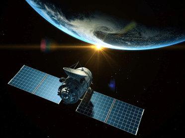
Satellites
Satellites serve a variety of purposes — from spying on foreign adversaries to tracking weather and improving cell service, or as mentioned above – enabling the GPS network.
https://www.google.com/url?sa=i&url=https%3A%2F%2Fwww.thoughtco.com%2Fweather-forecasting-satellites
n terms of map making, satellites enable consistent, large-scale updates of Earth’s surface.
Think about modern applications like Google Earth or cloud GIS tools. These all rely on satellites for accurate geospatial data.
Satellites have increased the speed and range at which mappable information can be collected. Surveys that once took months can now be done in minutes.
Geographic Information Systems (GIS)
Sensors, GPS, and satellites are methods through which to collect data.
These devices are quite advanced. However, as a general rule, they lack the ability to display, organize, and manage the data they collect.
GIS provides the ideal solution.
GIS is location-based software used to view, organize, visualize, and analyze geospatial data. GIS helps users wrangle their data, enabling a better understanding of positionally-based patterns and relationships.
MODERN TRENDS IN CARTOGRAPHY
Electronic cartography has been rapidly growing in the current marketplace as GPS technology becomes more intuitive. Marine electronic cartography specifically has taken off as GIS technology is used to map marine ecosystems and travel patterns.
The goal of marine electronic cartography is to make transportation via bodies of water more efficient than it was in the past with only paper charts Because this area of GIS technology is still growing, there is an increasing need for professionals in the field with expertise in cartography.
GIS professionals also have the opportunity to go into the commercial or defense markets to put their skills to use. According to Persistence Market Research, demand for marine electronic cartography is expected to increase worldwide meaning international positions will be readily available. The firm expects growth in the following areas through 2026:
- Marine infrastructure and vessel safety
- Increasing ocean trade activity
- Worldwide economic expansion
Modern cartography is also a great tool for understanding elections. This map collection vividly shows the political contrasts in the United States and breaks down the information in a number of ways. For example, local and federal governments use GIS technology for mapping elections and reaching targeted voter demographics.
Practical Applications of Modern Cartography
Most people interact with the products of modern cartography on a daily basis.
Consider the many apps on your phone. How many of them rely on location-based services? Navigation apps like Google Maps and Waze, ride services like Uber or Lyft, and food delivery apps like DoorDash all have some kind of mapping component.
That said, modern cartography goes far beyond simply finding your location on a map. Location intelligence, 3D modeling, and real-time map creation are all based on the application of modern cartographic tools.
Location Intelligence
Location intelligence, also known as spatial intelligence, helps users derive insights and discover meaningful relationships within geospatial data.

https://www.google.com/url?sa=i&url=https%3A%2F%2Fwww.buxtonco.com
Location intelligence emerged from the foundation of GIS and is used to help organizations and corporations understand positional data.
3D Modeling
LiDAR, one of the modern cartography tools mentioned above, is integral to creating 3D maps and models. LiDAR relies on laser light to measure distance.

Point cloud of slope failures in Sensuikyo Valley
A laser pulse is released, travels outward, hits an object, and then bounces back. Similar to sonar, distance is measured by how long the pulses take to return.
Because light travels incredibly fast and in all directions simultaneously, LiDAR scans produce point clouds.
MODERN TECHNIQUES IN CARTOGRAPHY
One of the key techniques used in modern cartography has its roots in 17th-century map-making. Relief shading techniques give dimension and depth to maps so individuals can better understand the terrain. GIS specialists can use applications like Photoshop and other digital software to create relief shading online.
For example, this map of Mars uses elevation data that lets visitors explore terrain across the red planet. This interactive map not only implements relief shading but also uses the essential tool of color coding to help users understand how Mars might look with bodies of water.
USC students interested in cartography have multiple paths toward enhancing their knowledge. The online M.S. in Geographic Information Science & Technology offers a comprehensive education in advanced GIST techniques, applications, and practices, with a specialized track for creating maps and visualizations. Students in the online graduate certificate in the GIST program gain a foundation in spatial data acquisition, and they can select cartography and visualization as an elective.


